
Town of Mahone Bay water supply
The Town of Mahone Bay, located on Nova Scotia's south shore, had without any issues used Oakland Lake for many years as a municipal water supply. However, in order to move forward with its water source protection program, it was required that the town register the water source and, in the process, it was necessary for the town to obtain a water taking permit from the province.
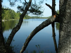
Water taking was metered at the lake and again at the water treatment plant just before distribution, but the watershed was not gauged, so there was no data on natural water flows in the watershed. The Town of Mahone Bay hired earth-water Concepts inc. to help obtain the necessary source registration and water taking permits. This required a comprehensive investigation that:
Fixed link to Prince Edward Island
This project proposed and eventually constructed a 13-km bridge between Prince Edward Island and the mainland of Canada between Borden, P.E.I., and Cape Tormentine, New Brunswick. The project consisted of a high-level two-lane road structure built on piers over the entire crossing of the Northumberland Strait, although a tunnel option had also been considered.
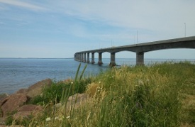
While working for others, and a part of the environmental impact assessment for the new bridge, the staff at earth-water Concepts inc. were asked to assess the groundwater supply and surface water hydrological implications of the tunnel option before the bridge was constructed. The assessment modelled the effects of advancing a tunnel through bedrock under salt water and into fresh water aquifers, and maintaining tunnel drainage through several years of operation. The results were delivered for consultation with the federal government and both provincial governments, and with members of the local communities at both landfall areas of the bridge.
The Town of Mahone Bay, located on Nova Scotia's south shore, had without any issues used Oakland Lake for many years as a municipal water supply. However, in order to move forward with its water source protection program, it was required that the town register the water source and, in the process, it was necessary for the town to obtain a water taking permit from the province.
Water taking was metered at the lake and again at the water treatment plant just before distribution, but the watershed was not gauged, so there was no data on natural water flows in the watershed. The Town of Mahone Bay hired earth-water Concepts inc. to help obtain the necessary source registration and water taking permits. This required a comprehensive investigation that:
- characterized growth in demand and estimated future water use from the Oakland Lake water source,
- collected precipitation, stream flow and water taking data to obtain proper water balance information for the watershed,
- simulated long-term source flows from nearby gauged watersheds,
- described downstream effects of water withdrawal from the lake,
- evaluated local yield under current and future demand conditions,
- mapped the lake bathymetry and defined lake water residence times,
- evaluated risks of contamination within all parts of the watershed and at the lake,
- evaluated the adequacy of the current lake storage and the need for increased reservoir storage into the future,
- systematically evaluated water supply options and long-term operating requirements for the watershed and water supply,
- obtained all necessary registrations and water taking permits.
Fixed link to Prince Edward Island
This project proposed and eventually constructed a 13-km bridge between Prince Edward Island and the mainland of Canada between Borden, P.E.I., and Cape Tormentine, New Brunswick. The project consisted of a high-level two-lane road structure built on piers over the entire crossing of the Northumberland Strait, although a tunnel option had also been considered.
While working for others, and a part of the environmental impact assessment for the new bridge, the staff at earth-water Concepts inc. were asked to assess the groundwater supply and surface water hydrological implications of the tunnel option before the bridge was constructed. The assessment modelled the effects of advancing a tunnel through bedrock under salt water and into fresh water aquifers, and maintaining tunnel drainage through several years of operation. The results were delivered for consultation with the federal government and both provincial governments, and with members of the local communities at both landfall areas of the bridge.
Shubenacadie private water supplies
The Municipality of the District of Hants was in the process of developing a groundwater supply within a shallow, confined, unconsolidated Cretaceous sand and gravel channel and delta aquifer complex in order to replace the surface source that was serving the village of Shubenacadie, Nova Scotia. Aquifer recharge, which was thought to be occurring a long distance away, was poorly understood, and the planned additional aquifer withdrawals by the municipality were significant.
This caused a number of local farm operators to raise concerns that possibly limited aquifer resources, which in Nova Scotia are allocated on a first come first serve basis, may not be correctly appropriated in order to meet their existing well demands and farm water supply requirements.
To ensure proper recognition and fair allocation of the water resources that were already in use, local farm owners hired earth-water Concepts inc. to obtain groundwater withdrawal approvals for a number of existing water supply wells. This required that a number of pumping tests and studies be done to assess and document:
Fox Harb'r golf course and marina
Fox Harb'r is a luxury resort located on the Northumberland Straight in Nova Scotia. The site contains a golf course, several condominiums, a jet landing strip, and a salt water marina. Construction of the marina required extensive excavation and dewatering before it could finally be flooded with sea water.
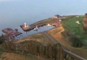
The owners and managers of the Fox Harb'r facility hired earth-water Concepts inc. to help address concerns and allegations by nearby cottage well owners that construction of the marina might be affecting their shallow wells. The site assessment included a review of all existing wells, consultation with the nearby well owners and the site project managers, groundwater data collection, and groundwater modelling in order to develop an appropriate groundwater management and construction mitigation plan. The plan was presented to and accepted by all involved.
The Municipality of the District of Hants was in the process of developing a groundwater supply within a shallow, confined, unconsolidated Cretaceous sand and gravel channel and delta aquifer complex in order to replace the surface source that was serving the village of Shubenacadie, Nova Scotia. Aquifer recharge, which was thought to be occurring a long distance away, was poorly understood, and the planned additional aquifer withdrawals by the municipality were significant.
This caused a number of local farm operators to raise concerns that possibly limited aquifer resources, which in Nova Scotia are allocated on a first come first serve basis, may not be correctly appropriated in order to meet their existing well demands and farm water supply requirements.
To ensure proper recognition and fair allocation of the water resources that were already in use, local farm owners hired earth-water Concepts inc. to obtain groundwater withdrawal approvals for a number of existing water supply wells. This required that a number of pumping tests and studies be done to assess and document:
- the overall local aquifer and existing individual well capabilities,
- current demand and future farm groundwater supply requirements,
- mutual influences that pumping at the farm wells might have on other nearby farm wells and on the proposed new municipal water supply,
- production sustainability relative to the then current understanding of aquifer recharge,
- fair allocation of water resources for use by the area farms and appropriate pumping rates for permit applications,
- acquisition of the necessary groundwater withdrawal approvals for the farm water supplies.
Fox Harb'r golf course and marina
Fox Harb'r is a luxury resort located on the Northumberland Straight in Nova Scotia. The site contains a golf course, several condominiums, a jet landing strip, and a salt water marina. Construction of the marina required extensive excavation and dewatering before it could finally be flooded with sea water.
The owners and managers of the Fox Harb'r facility hired earth-water Concepts inc. to help address concerns and allegations by nearby cottage well owners that construction of the marina might be affecting their shallow wells. The site assessment included a review of all existing wells, consultation with the nearby well owners and the site project managers, groundwater data collection, and groundwater modelling in order to develop an appropriate groundwater management and construction mitigation plan. The plan was presented to and accepted by all involved.

